
Importing Survey Data
|
Survey Import functions are disabled if you work in the Production View. Authoring functions, including updating a project, are always performed against a work order or a standing task, and always in a Work In Progress (or WIP) view that until it is published, is only visible to users working in the work order or standing task. |

Survey data can be imported into an asset database (while working in a work order or standing task) using one of these formats:
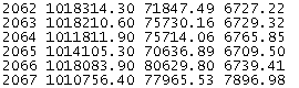
- ASCII text files which are either space, tab, or comma delimited. An example of a space delimited text file is:
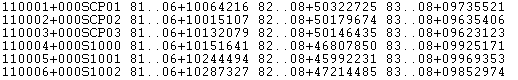
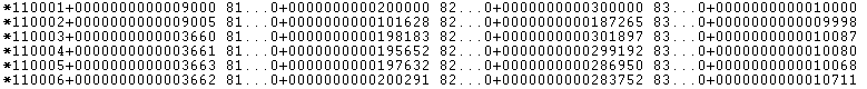
- 8-bit and 16-bit GSI files. Examples of the supported 8 bit and 16 bit GSI formats are:
Import Survey Data
You can import survey data by either:
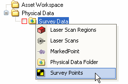
- Selecting a physical data folder from the Asset Explorer, right-clicking to display the Context menu and going to Create - Survey Points
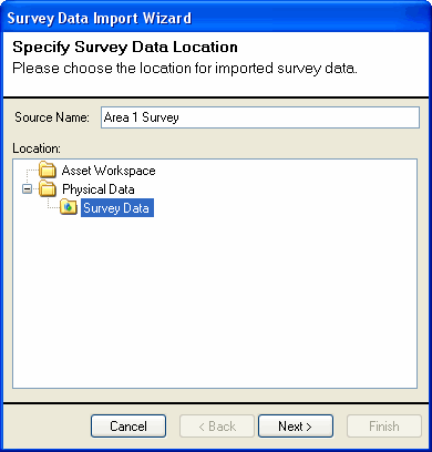
- Clicking on the Import Survey Data button in the Physical Data Manager. This will present the Survey Data Import Wizard;
- Specify a name for the name of the source data. This will be used to identify the data in the Physical Data Manager.
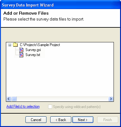
- Add one or more files to the source by browsing the hard drive.
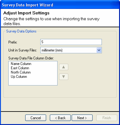
- If you are importing ASCII files, you can specify a prefix for each of the survey points, the units of the coordinates in the survey text file (if a unit is missing, you can define a new unit in the Project Settings), and the order of the data in the text file. For example, if the coordinates are in the order of Elevation, East, and North, select Up Column and use the arrows to move it 2 spaces. These options are disabled if you are importing a GSI file.
- The progress dialog may display any errors encountered while reading the file. If the import was successful, click Finish to end the import.
Survey Data Synchronization
If the survey data changes after the import, you can synchronize the survey data from the Physical Data Manager. The following scenarios are covered during synchronization:
- A new line in the survey text file has been added representing a new point will result in a new Survey Point being created.
- A line in the survey text file has been changed will result in the position of the survey point with the same name to be changed.
- A line in the survey text file has been deleted will result in the Survey Point being deleted.